English
English
Appearance
Geoinformation solutions for the management of nature reserves
Effective management of urban green spaces is not only a matter of aesthetics but also ecology, safety, and comfort for residents. Itree is an innovative system that automates the accounting, monitoring, and development of green spaces, allowing cities to save resources and quickly solve problems.
From chaotic maintenance to smart management
Rational management of green areas based on up-to-date data significantly reduces costs. Users have constant access to historical data, allowing them to analyze changes and make informed decisions.
With tools for collecting feedback from citizens, Itree encourages active public participation in the care of green areas, improving their condition and maintenance quality.
Itree is built on open standards and integrates seamlessly with other IT systems. This allows for full control of data and the ability to use it in external analytical tools.
Updated monitoring of green areas and public recreation zones helps reduce the risk of accidents. Itree tracks the condition of trees, playgrounds, and other infrastructure elements.
Itree uses modern data collection technologies, environmental sensors, NFC and RFID tags. We are constantly improving the system, introducing the latest developments in the field of urban greening.
Itree adapts to the needs of different users. The system allows you to create individual workflows, configure access rights, and integrate new modules according to the specifics of each city or enterprise.
What allows?
What can citizens do?
What does the functionality provide?
What does the system analyze and predict?


Automate workflows, engage the community, and manage green spaces with innovative modules.

Involve your city's residents. This module creates a direct connection between citizens and the city administration. Users can leave requests regarding the condition of green zones, and the system automatically records them on the map, tracks the status, and allows you to effectively manage the work.

Organize and manage events easily. All events related to green areas are easily added and displayed on the map. Automatic event distribution allows residents to stay up to date with all changes in their favorite parks and squares.
Monitor the condition of trees with high accuracy. The module allows you to keep records of inspections, form commissions and automatically generate acts based on templates. All management is in your hands – from applications to final reports.

A modern approach to accounting for green spaces. Thanks to integration with barcodes and QR codes, each tree receives a unique identifier. Fast scanning allows you to instantly find information about the object and simplifies auditing.

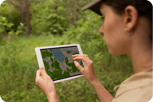
Make your map even more informative. Tree markers change size based on their height, allowing you to quickly assess the overall condition of the stands.

Deep analytics for decision-making. The system allows you to filter and analyze data by type, condition, and number of trees in any area. Data visualization in the form of a dynamic map helps assess the effectiveness of landscaping.
Ukrainian cities achieve tangible results by working with us. From accurate accounting and optimization of city resources to improved planning and effective management. Find out how our solutions change reality.

Odesa has made a digital breakthrough in green zone management. An interactive portal allows the city to monitor the condition of trees, plan improvements, and engage the community in changes. Innovative registers of recreation areas, plantings, and improvements, convenient map integration, and the ability to leave comments – all this makes the platform an indispensable tool for the city’s development.

Bila Tserkva has taken a step into the future with “SMART Green BTs” – an innovative green zone management system. An interactive portal, mobile application and advanced analytics allow the city to effectively manage plantings, and residents to participate in the care of parks, squares, etc. Digitized data, flexible filters, the possibility of financial support and interactive promotions make this project a real breakthrough.
Answers to the most frequently asked questions.
Itree contains a spatial database covering all green space objects. The software allows you to plan maintenance work, record problems with attaching photos and documents, and assess the condition of trees and other objects.
Through the Itree mobile application, users can document the work carried out in real time. Objects are marked with unique numbers or RFID tags, which ensures full control and transparency of operations.
The system allows you to keep detailed records of trees, parks, and green areas, plan maintenance, find problem areas, and optimize landscaping costs.
Yes! You can view information about the condition of green areas, report problems (broken branches, dead trees, etc.), and even support greening financially or through volunteer participation.
Yes, the system is flexible and can be adapted for any settlement - from megacities to small communities.
iTree is not just a tree map, but an analytical tool that allows you not only to see data, but also to make decisions, plan work, and effectively allocate resources.
Let's begin
Having a technical issue? Want to provide feedback on a beta feature? Need information about our business plan? Let us know.